Météo hyper-locale et cartographie des risques opérationnels : sécuriser l’agriculture et les territoires face aux crises
Publié le26 mars 2026
Dans de nombreuses organisations, les données météo locales existent déjà. Des outils d’analyse permettent de suivre des courbes d’évolution ou de déclencher des alertes régionales. Pourtant, lorsqu’il s’agit de décider sur le terrain, coordonner une équipe de secours, déclencher une intervention ou lancer un traitement agricole, ces informations restent souvent isolées et déconnectées de la … Météo hyper-locale et cartographie des risques opérationnels : sécuriser l’agriculture et les territoires face aux crises
Météo hyper-locale et cartographie des risques opérationnels : sécuriser l’agriculture et les territoires face aux crises
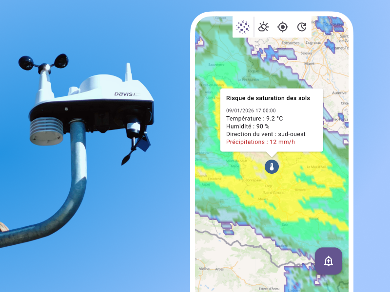
Application Kalisio Maps alertant d’un risque de saturation des sols grâces aux croisements de données météos et de la balise locale Weatherlink
Dans de nombreuses organisations, les données météo locales existent déjà. Des outils d’analyse permettent de suivre des courbes d’évolution ou de déclencher des alertes régionales.
Pourtant, lorsqu’il s’agit de décider sur le terrain, coordonner une équipe de secours, déclencher une intervention ou lancer un traitement agricole, ces informations restent souvent isolées et déconnectées de la réalité du terrain.
C’est cette fracture entre la donnée et l’action qui limite encore aujourd’hui leur utilisation, aussi bien en gestion de crise que dans les filières agricoles.
Le décalage entre météo régionale et réalité locale
Dans une région comme l’Occitanie, les phénomènes climatiques sont de plus en plus imprévisibles et localisés. Les épisodes cévenols, les gels tardifs ou les orages intenses touchent certaines parcelles ou communes et épargnent celles d’à côté.
Les communes font face à des routes inondées ou des éboulements sur des secteurs précis, alors que le reste du territoire reste praticable.
Dans ce contexte, la météo moyenne régionale perd sa valeur opérationnelle. Ce qui compte, c’est ce qui se passe ici et maintenant, à l’échelle d’une parcelle, d’une route ou d’un site sensible.
La différence se joue parfois à quelques centaines de mètres.
Les crises climatiques de 2025-2026 ont d’ailleurs mis en évidence les limites des modèles généraux.
Pour l’agriculteur : Une grêle le 18 avril dans les Cévennes touche une parcelle sur deux, laissant l’autre indemne.
Pour le Maire : Un orage violent en Haute-Garonne bloque des routes spécifiques par éboulement, tandis que le reste de la commune est épargné.
Pour l’assureur : En l’absence de données précises, les situations restent difficiles à qualifier, y compris dans le cadre d’expertises d’assurance.
Pour les acteurs de terrain, responsables de CUMA (Coopérative d’Utilisation de Matériel Agricole), chefs de culture ou gestionnaires de crise, un besoin émerge : savoir où intervenir, quand agir et comment coordonner les actions face à des aléas qui ne respectent pas les limites administratives.
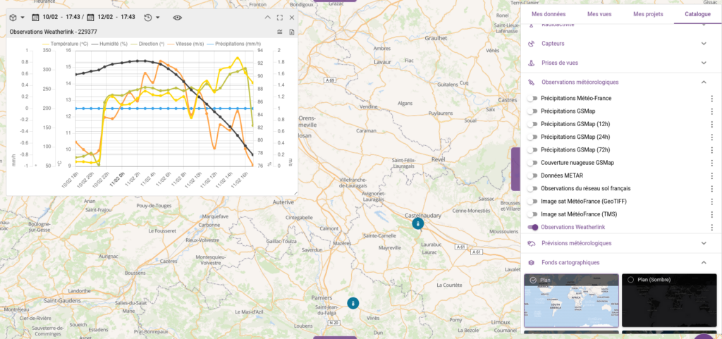
C’est pour répondre à ce besoin que Kalisio a intégré les données de stations connectéesWeatherLink dans sa solution cartographique Kalisio Maps.
L’objectif n’est pas d’ajouter une source de données supplémentaire, mais d’en transformer l’usage : faire de la météo un outil de sécurisation pour les territoires et les activités agricoles.
Sur la carte, la donnée est localisée, contextualisée et reliée aux enjeux du terrain. Qu’il s’agisse d’infrastructures, de parcelles agricoles ou de zones à risque.
Gestion de crise : l’exemple de Bormes-les-Mimosas
La commune de Bormes-les-Mimosas est à l’origine de notre démarche.
Dans le cadre de son Plan Communal de Sauvegarde (PCS), elle a déployé Kalisio Crisis pour équiper son Poste de Commandement Communal (PCC). Ce dispositif est dédié à la coordination des actions en situation de crise.
Comme l’explique Samuel Legigan, responsable du service Sécurité Civile Communale :
“Cette solution correspond aux attentes d’une collectivité comme la nôtre : une cartographie opérationnelle, une main-courante, mais surtout un suivi des actions sur le terrain.”
L’intégration des données météo locales vise à aller plus loin dans les usages opérationnels. À terme, les équipes pourront visualiser l’impact localisé des intempéries et anticiper les risques (inondations, ruissellement, chutes de matériaux). Ils partageront une information fiable avec les partenaires institutionnels comme le SDIS ou la Gendarmerie.
Agriculture de précision : un levier économique et environnemental
Au-delà de la gestion de crise, l’agriculture est le secteur où cette fusion données/cartes change la donne économique et environnementale.
L’agriculture représente environ 10 à 12 % des prélèvements d’eau douce en France, principalement pour l’irrigation, selon le Service des données et études statistiques.
En croisant les données de pluie locale avec l’évapotranspiration, les exploitants peuvent ajuster leurs apports en eau avec précision. L’irrigation devient plus efficace, plus sobre, et mieux adaptée aux besoins réels des cultures.
Les traitements phytosanitaires reposent sur la même logique. Leur efficacité dépend directement des conditions météorologiques. Des acteurs comme Syngenta rappellent qu’un vent trop fort, supérieur à 15-19 km/h, ou une hygrométrie insuffisante entraînent une dérive des produits, réduisant leur efficacité et augmentant leur impact environnemental.
Une lecture fine des conditions locales permet d’intervenir uniquement lorsque les conditions sont réunies, limitant les doses et sécurisant les pratiques.
Une vision partagée et opérationnelle du territoire
L’un des apports majeurs de l’intégration cartographique réside dans la capacité à partager et croiser les données à l’échelle d’un territoire.
Une CUMA (Coopérative d’Utilisation de Matériel Agricole) ou une coopérative peut ainsi suivre plusieurs stations réparties sur différentes exploitations, visualiser en temps réel un épisode cévenol et coordonner rapidement ses actions. Qu’il s’agisse de mobiliser du matériel ou d’organiser l’entraide entre agriculteurs.
Une collectivité peut croiser les données météo avec ses zones à risque, comme les PPRI (Plans de Prévention du Risque Inondation), ses infrastructures ou son réseau routier, afin d’anticiper les impacts d’un événement.
Cette mise en réseau permet de passer d’une vision fragmentée à une lecture cohérente et partagée du territoire. Elle ouvre également la voie à des usages plus avancés.
En agriculture, la combinaison des données météo et de la localisation des cultures permet par exemple d’identifier les conditions favorables au développement de maladies comme le mildiou ou l’oïdium.
Elle peut anticiper les épisodes de gel à partir de l’historique de l’humidité, de la température et des précipitations.
L’historisation des données constitue un atout clé pour la gestion des sinistres. En cas d’aléa climatique, il devient possible de démontrer précisément qu’un événement a bien eu lieu à un endroit donné, à un moment donné, facilitant ainsi les expertises et les processus d’indemnisation.
Sur une même interface, il devient possible de visualiser le vent sur des zones de chantier, la pluie sur des secteurs inondables ou encore l’historique des traitements sur des parcelles agricoles déclarées (PAC).
Accessible sur mobile comme sur poste fixe, partagée entre différents acteurs et connectée aux OAD (Outils d’Aide à la Décision) via API, cette approche évite la multiplication des outils et facilite une coordination rapide entre agriculteurs, collectivités et services de secours.
Vers des territoires plus résilients
Que ce soit pour sécuriser une intervention en situation de crise ou piloter une exploitation agricole, l’enjeu n’est plus seulement d’accéder à la donnée, mais de pouvoir l’exploiter immédiatement dans son contexte.
En intégrant la météo hyper-locale dans Kalisio Maps, les organisations disposent d’un outil qui relie directement observation et action, et qui permet d’anticiper, coordonner et adapter leurs décisions face à des événements de plus en plus localisés.
Vous souhaitez intégrer vos données météo à votre cartographie opérationnelle ?
Toute l’équipe Kalisio vous adresse ses meilleurs vœux pour cette nouvelle année, placée sous le signe de l’innovation, de la collaboration et de l’ambition partagée. 2025 a été une année particulièrement riche :🚀De nombreux projets menés avec succès, structurants pour nos clients🎙 Une forte dynamique de R&D, marquée par le clap de fin d’un projet France 2030🤝 Une … Bonne année 2026 !
Toute l’équipe Kalisio vous adresse ses meilleurs vœux pour cette nouvelle année, placée sous le signe de l’innovation, de la collaboration et de l’ambition partagée.
2025 a été une année particulièrement riche : 🚀De nombreux projets menés avec succès, structurants pour nos clients 🎙 Une forte dynamique de R&D, marquée par le clap de fin d’un projet France 2030 🤝 Une équipe qui s’est renforcée avec l’arrivée de nouveaux collaborateurs
2026 s’annonce tout aussi intense et stimulante, avec : 👉🏼 La poursuite de nos projets majeurs aux côtés de nos clients historiques 👉🏼 Une refonte de notre ligne et de nos offres, menée en étroite collaboration avec nos partenaires, dontKrisis, que nous remercions chaleureusement pour leur engagement à nos côtés Merci à nos clients, partenaires et équipes pour leur confiance et leur énergie. Cap sur 2026, avec la même exigence, la même passion et encore plus d’envie de construire l’avenir ensemble 🚀
L’expertise technique de Kalisio Maps au service d’Airbus
Publié le16 décembre 2025
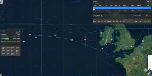
🚀 L’équipe Kalisio est fière de voir son expertise technique mise en valeur dans le cadre du projet Fellow’Fly d’Airbus, qui vise à récupérer l’énergie de sillage pour réduire la consommation de carburant sans devoir apporter de modification à ses avions. 🔎 Ainsi, notre solution cartographique collaborative temps-réel Kalisio Maps (aka Kano) accompagne les équipes … L’expertise technique de Kalisio Maps au service d’Airbus
L’expertise technique de Kalisio Maps au service d’Airbus
🚀 L’équipe Kalisio est fière de voir son expertise technique mise en valeur dans le cadre du projet Fellow’Fly d’Airbus, qui vise à récupérer l’énergie de sillage pour réduire la consommation de carburant sans devoir apporter de modification à ses avions.
🔎 Ainsi, notre solution cartographique collaborative temps-réel Kalisio Maps (akaKano) accompagne les équipes d’Airbus tout au long de leurs essais. Notre participation permet au projet de bénéficier de nos contributions dans le cadre de la plateformeGIFT, qui fournit des services géographiques temps-réel à un écosystème d’applications dédiées aux essais en vol.
🌟 Cette collaboration illustre la capacité d’un acteur du logiciel et de la donnée cartographique libre à apporter des solutions innovantes et opérationnelles au domaine aéronautique.
Pour offrir les meilleures expériences, nous utilisons des technologies telles que les cookies pour stocker et/ou accéder aux informations des appareils. Le fait de consentir à ces technologies nous permettra de traiter des données telles que le comportement de navigation ou les ID uniques sur ce site. Le fait de ne pas consentir ou de retirer son consentement peut avoir un effet négatif sur certaines caractéristiques et fonctions.
Fonctionnel
Toujours activé
L’accès ou le stockage technique est strictement nécessaire dans la finalité d’intérêt légitime de permettre l’utilisation d’un service spécifique explicitement demandé par l’abonné ou l’utilisateur, ou dans le seul but d’effectuer la transmission d’une communication sur un réseau de communications électroniques.
Préférences
L’accès ou le stockage technique est nécessaire dans la finalité d’intérêt légitime de stocker des préférences qui ne sont pas demandées par l’abonné ou l’internaute.
Statistiques
Le stockage ou l’accès technique qui est utilisé exclusivement à des fins statistiques.Le stockage ou l’accès technique qui est utilisé exclusivement dans des finalités statistiques anonymes. En l’absence d’une assignation à comparaître, d’une conformité volontaire de la part de votre fournisseur d’accès à internet ou d’enregistrements supplémentaires provenant d’une tierce partie, les informations stockées ou extraites à cette seule fin ne peuvent généralement pas être utilisées pour vous identifier.
Marketing
L’accès ou le stockage technique est nécessaire pour créer des profils d’internautes afin d’envoyer des publicités, ou pour suivre l’utilisateur sur un site web ou sur plusieurs sites web ayant des finalités marketing similaires.