In early September 2026, the United Nations General Assembly adopted, by an overwhelming majority, a resolution encouraging the use of “area-preserving” projections, such as Equal Earth, to better represent the relative sizes of the continents.
In practical terms, this does not mean banning the Mercator projection. It is a political and symbolic guideline that invites governments, educational institutions, international organizations, and technology companies to reconsider how they represent the world on their maps.
For a provider of B2B mapping solutions like Kalisio, this raises a question: Should we switch to a different projection, and more importantly, how do we choose the right projection for specific uses without disrupting existing tools?
Why Is the UN Interested in Map Projections?
The “Correct the Map” resolution, sponsored by several African states and co-sponsored by France, was adopted by a vote of 164 in favor, 1 against, and 6 abstentions.
It encourages the use of equal-area projections—particularly Equal Earth—when comparing land areas is important. It is part of a broader discussion on the choice of projections based on their intended uses: the Mercator projection, for example, retains properties that are useful for certain navigation purposes.
It is therefore not a technical standard requiring the replacement of the Mercator projection. But the message is clear: the projection used to represent the world influences the way we perceive territories.
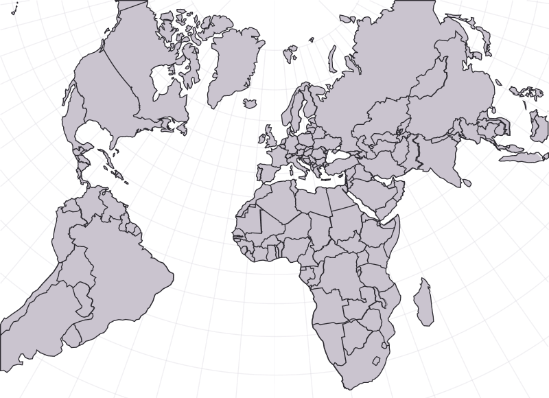
Mercator: A Practical Map, but with distorted areas
The Mercator projection, developed in 1569 by the Flemish cartographer Gerardus Mercator for navigation, preserves angles and thus facilitates certain uses related to orientation.
On the other hand, it significantly distorts land areas as one moves away from the equator.
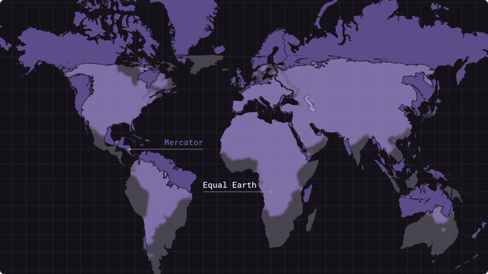
- Greenland appears to be roughly the same size as Africa, whereas in reality Africa is about 14 times larger;
- Europe and North America appear disproportionately larger than equatorial regions.
It is this cognitive distortion—rather than a technical error—that the UN resolution aims to correct.
The problem arises when this projection is used to visually compare areas or represent relationships between territories.
Mercator, Lambert-93, Equal Earth: Which projection for which purpose?
There is no single ideal map projection for all purposes. The choice depends on the scale, the data being represented, and, above all, what you intend to do with the map.
Web Mercator: The de facto standard for web mapping
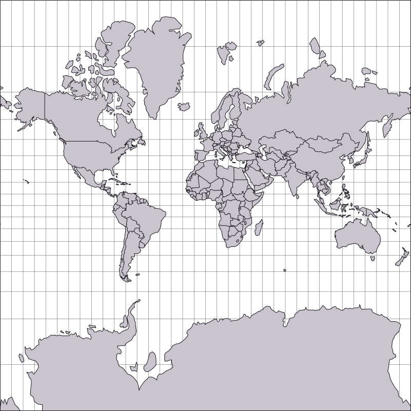
On the web, the dominant projection is Web Mercator (EPSG:3857), which was widely popularized by Google Maps and subsequently adopted by much of the mapping ecosystem, including OpenStreetMap and numerous JavaScript libraries.
Its success can be attributed in particular to:
- a simple and effective overlapping system;
- extensive compatibility with base maps and map libraries;
- a mature ecosystem for interactive maps.
Its main limitation is the significant distortion of areas at high latitudes.
Web Mercator therefore remains particularly well-suited for interactive maps, navigation, and geolocation, but less so for the visual comparison of areas on a global scale.
Lambert-93: A projection system suited for Metropolitan France
In France, official mapping has been based since the 2000s on:
- the RGF93 geodetic system (compatible with WGS84/ETRS89);
- the Lambert-93 projection (EPSG:2154), a conformal conic projection optimized for metropolitan France.
It offers :
- coordinates in meters, with a linear error generally less than 1 m/km across most of the territory;
- a consistent framework for integrating cadastral data, IGN layers, and departmental and regional data.
For applications requiring greater precision—such as surveying, cadastral mapping, or certain uses related to drones and networks—locally conformal conic projections, notably the CC42 through CC50 projections, sometimes referred to as Lambert-93 CC or Lambert CC9 zones, may also be used.
Equal Earth: A global projection that respects surface areas
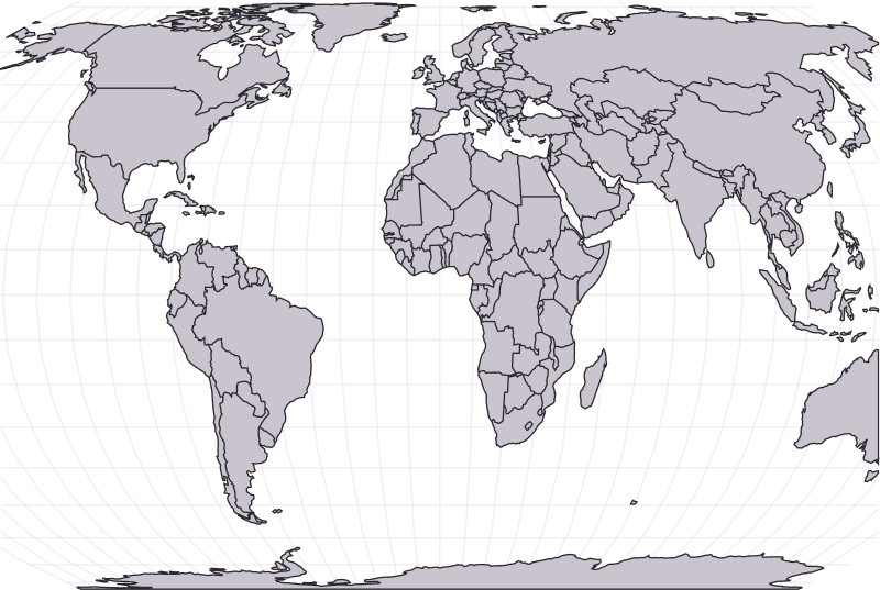
Equal Earth projection
Equal Earth is a pseudo-cylindrical projection with equal surface area, created in 2017–2018 to provide:
- a more accurate representation of continental landmasses than the Mercator projection;
- an aesthetic similar to that of the Mercator projection (recognizable continents, curved meridians that aren’t too “exotic”), unlike some other, more radical equal-area projections (e.g., Gall–Peters).
However, it does not preserve angles or distances. It is therefore not intended to replace the Mercator projection in applications where angle preservation or navigation is a priority.
Equal Earth addresses a different problem: representing land areas more accurately on a global scale. It is not, in fact, the only equal-area projection. The Eckert IV, an equivalent pseudocylindrical projection introduced in 1906, offers another solution for world maps. France recently chose this projection for some of its official world maps, rather than adopting Equal Earth.
Other projections, such as Gall–Peters, Robinson, or Winkel Tripel, strike different balances between areas, shapes, distances, and angles.
Switching from Mercator to Equal Earth: What needs to be changed?
On paper, “adopting Equal Earth” seems simple: just change the projection. In practice, this affects:
- basemaps and tiles;
- mapping libraries (MapLibre, Leaflet, OpenLayers, etc.);
- vector data (GeoJSON, internal databases);
- UX (zoom, scaling, visual landmarks, interactions).
The question, then, is less “How can we replace the Mercator projection?” than “Where and when does another projection actually add value?”
On a global scale: using Equal Earth to get the big picture
For a world map designed to display territories, environmental data, or comparative indicators, Equal Earth can be an interesting alternative to Web Mercator.
Solutions already exist for experimenting with this approach:
- Use a plugin such as maplibre-gl-equal-earth, which adds basic, experimental support for the Equal Earth projection to MapLibre GL JS.
- It allows you to load styles and tiles in Equal Earth and convert coordinates between Equal Earth and Mercator depending on the zoom level;
- Example of use: Equal Earth tiles up to a certain zoom level, then switch to Mercator tiles for more detail.
- Adopt dedicated base maps (for example, those hosted on equal.bbox.earth) designed for Equal Earth, and combine them with vector layers that are reprojected on the fly.
One possible architecture involves using Equal Earth for the global view, then switching to a more appropriate projection when the user zooms in on a specific geographic area.
The goal, therefore, is not necessarily to choose a single projection for the entire application, but to be able to adapt the representation based on scale and use.
What about France?
For France, a coherent architecture could involve a sequence of projections based on the zoom level:
- global view: Equal Earth or another projection with equal surface area for comparing territories;
- at the European or national level: a gradual transition toward a projection better suited to the regional scale;
- Detailed view of metropolitan France: Lambert-93 (EPSG:2154) or, for very specific purposes, the local conformal conic projections CC42–CC50.
Technically, this involves determining at which zoom levels the projection changes occur and reprojecting the data into the corresponding coordinate reference system (CRS). For example:
- z ≤ 4 : Equal Earth ;
- 5 ≤ z ≤ 8 :European projection or transitional Mercator projection;
- z ≥ 9 : Lambert-93 for metropolitan France, or a UTM projection appropriate for the displayed overseas territory.
These values are provided as examples. The thresholds naturally depend on the data, the application, the geographic scope, and the intended uses: there is no one-size-fits-all approach.
Reprojection can be performed upstream—for example, in an ETL pipeline or using tools such as PostGIS or QGIS—or on the fly on the server or client side.
This process must also take into account the geographic scope. Lambert-93 is suitable for metropolitan France, while the overseas departments and regions have coordinate systems and projections tailored to their geographic locations.
IGN data may therefore be available—depending on the territory and dataset—in UTM20 for the French West Indies, UTM22 for French Guiana, UTM40 South for Réunion, and UTM38 South for Mayotte, with geodetic reference frames tailored to each territory, such as RGAF09, RGFG95, RGR92, or RGM23.
For a mapping platform covering the entire French territory, the choice of projection therefore depends not only on the zoom level but also on the geographic scope: Lambert-93 can be used for metropolitan France, while a UTM projection or another local CRS will be more appropriate for an overseas territory. The application must then manage the data, tiles, and transformations corresponding to each territory.
The limits of Equal Earth: a projection can’t do everything
Like any map projection, Equal Earth introduces distortions. Shapes, angles, and distances are not preserved, and the distortions become particularly noticeable near the poles and at the edges of the map, where the curved meridians stretch the borders of countries.
Consequences:
- Countries located at the edges of the map (such as certain islands, overseas territories, or regions at extreme longitudes) appear noticeably distorted;
- For applications where local context matters (land-use planning, detailed analysis of borders, intuitive understanding of the territory), this can be problematic, or even counterproductive.
Therefore, there is no such thing as a “bad” map projection in and of itself. Each projection is a compromise suited to certain uses.
So here’s a simple rule to remember:
- Equal Earth for global perspectives in the areas of education, politics, corporate social responsibility, and communications;
- Mercator / Web Mercator for navigation, precise geolocation tools, and operational maps;
- Lambert-93 / conformal conic projections for specific applications in France (cadastral surveying, topography, drones, networks).
And when the goal is to represent the Earth without using a flat projection, the globe 3D offers yet another approach.
Will Mercator really disappear from the web?
In the short term, it is unlikely that the UN resolution will lead to the disappearance of Mercator from digital maps.
Major mapping services and the majority of web applications will continue to use Web Mercator for reasons related to ecosystem, performance, and compatibility.
However, the resolution could contribute to an increase in the number of maps using equal-area projections in:
- education;
- public communication;
- institutional reports;
- visualizations of environmental data;
- CSR materials.
The real change, then, might not so much be the disappearance of the Mercator projection as the ability to choose a projection more consciously based on the message one wishes to convey.
OpenStreetMap: Data, multiple representations
The debate surrounding Equal Earth is also taking place within the OpenStreetMap community. Some members have proposed adding an Equal Earth view to osm.org, while retaining Web Mercator for uses where that projection remains relevant.
The discussion highlights an important distinction: OpenStreetMap primarily provides geographic data; how this data is represented on a map can then vary depending on the needs of the application.
OpenStreetMap data is provided in WGS84 geographic coordinates. An application can then display it in Web Mercator or another projection, depending on the needs of the service using it. It is therefore possible to produce OSM-based maps in projections other than Mercator.
Furthermore, the issue of non-Mercator projections is officially under consideration in the roadmap MapLibre GL JS.
What lesson can we learn from this?
The UN resolution does not impose a technical requirement to replace the Mercator projection with Equal Earth.
Rather, it highlights an important principle for mapping platforms: the choice of projection should depend on the intended use.
The challenge is to evolve maps without disrupting existing uses: adapting tiles, data, libraries, and interactions based on coverage and level of detail.
For a mapping platform, this ability to adapt the representation to the data, scale, geographic scope, and intended uses is also a key architectural consideration.
The real question is not “Which is the best projection?” but “Which projection is best suited for which use?”