Kalisio solutions are part of the Airbus Dragonfly project

📣 We are proud of the fact that GIFT (Geographical Information system for Flight Test), a platform we develop and operate for Airbus, is part of the Dragonfly project supported by Airbus UpNext.

💡 Dragonfly aims at evaluating how new technologies can:
✔ offer pilots assistance to manage taxi phases on crowded airports,
✔ extend the capability of automatic landing everywhere, especially on airports not equipped with ILS,
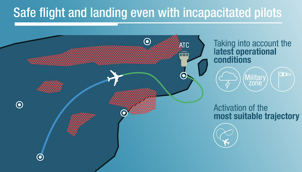
✔ give the capability of automatic diversion in an unlikely case of human incapacity.

👉🏼 Watch this video for more information about the project.

👉🏼 Read this article for more information about GIFT.

Kalisio is looking for a DevOps Engineer

👫 Who are we looking for?

  • Holder of a computer science degree (bachelor’s degree or higher)
  • Having a first significant experience of infrastructure maintenance in a production context.
  • Experienced with Kubernetes/Helm/Docker/Git/Linux technologies.

🎯 What missions await you?

  • Participation in the maintenance in operational conditions of our service infrastructures (public/private cloud).
  • Rationalization and continuous improvement of our integration and deployment system (CI/CD),
  • Contribution to Green IT actions on services
  • Writing procedures and sharing knowledge with our teams.

💪 What can make the difference?

You also have experience in one of the following areas: 

  • web / mobile / hybrid development,
  • monitoring tools (eg Prometheus / Grafana).

Who are we?

  • Experts in the development of innovative web geospatial solutions to assess the environment in real time (eg Kano  or Akt'n'Map).
  • Actors driven by the Open Source and Open Data philosophy (see https://github.com/kalisio & https://github.com/weacast).
  • A team on a human scale but carrying out several large-scale projects with major accounts.

🏠 What's different about Kalisio?

We work 100% remotely because we do not have any office. While we can meet on a regular basis whenever required, and our work environment has been specifically designed for remote collaboration, we also recognize that being part of a fully remote company is not for everyone. .

From savings on office space and transportation to greater flexibility in day-to-day life, we believe fully remote working offers a number of benefits for organizations, their employees, and the environment. Nevertheless, it also requires being in agreement with a particular philosophy to be experienced in a positive way: we favor an asynchronous mode of communication, we place great value on autonomy and results, we write down our know-how as much as possible (documentation, procedures, articles).

✔️ What conditions?

  • Salary according to experience
  • Health insurance
  • 100 % telework with reimbursement of related costs

📧 How to apply?

Send your CV, possibly with a cover letter, to Cette adresse e-mail est protégée contre les robots spammeurs. Vous devez activer le JavaScript pour la visualiser.

Kalisio is looking for a Web Developer

👫 Who are we looking for?

  • Holder of a computer science degree (bachelor’s degree or higher).
  • Having a first significant experience in the development of web solutions.
  • Experienced with the most popular web technologies (eg HTML5, VueJS, ExpressJS, Git).

🎯 What missions await you?

  • The realization of developments within our ecosystem of solutions.
  • Rationalization and continuous improvement of our ecosystem to ensure its sustainability.
  • Participation in custom projects for our customers (specifications, architecture, development, validation).
  • Knowledge sharing with our teams.

💪 What can make the difference?

You also have experience in one of the following areas: 

  • mobile/hybrid development,
  • NoSQL databases,
  • map data management,
  • Open Source project development.

Who are we?

  • Experts in the development of innovative web geospatial solutions to assess the environment in real time (eg Kano  or Akt'n'Map).
  • Actors driven by the Open Source and Open Data philosophy (see https://github.com/kalisio & https://github.com/weacast).
  • A team on a human scale but carrying out several large-scale projects with major accounts.

🏠 What's different about Kalisio?

We work 100% remotely because we do not have any office. While we can meet on a regular basis whenever required, and our work environment has been specifically designed for remote collaboration, we also recognize that being part of a fully remote company is not for everyone. .

From savings on office space and transportation to greater flexibility in day-to-day life, we believe fully remote working offers a number of benefits for organizations, their employees, and the environment. Nevertheless, it also requires being in agreement with a particular philosophy to be experienced in a positive way: we favor an asynchronous mode of communication, we place great value on autonomy and results, we write down our know-how as much as possible (documentation, procedures, articles).

✔️ What conditions?

  • Salary according to experience
  • Health insurance
  • 100 % telework with reimbursement of related costs

📧 How to apply?

Send your CV, possibly with a cover letter, to Cette adresse e-mail est protégée contre les robots spammeurs. Vous devez activer le JavaScript pour la visualiser.

Kalisio and Global Smart Rescue teamed up

Kalisio and Global Smart Rescue have signed a partnership to provide an end-to-end solution for risk management, from data acquisition to operations management. It combines the know-how of both companies to cover a wide range of use cases for civil security, defense or industry:

  • smart environmental data capture and analysis,
  • resilient communication and automated alert ,
  • real-time mapping of field operations and crisis management assistance.

The Natural Disasters Expo will be the first opportunity to get feedback from the US market about this new offering.

Enhanced User Experience with New Online Map Service

CLERMONT-FERRAND, France – September 21, 2021PlanetObserver and Kalisio reveal My Planet Maps, a new subscription-based online map service that delivers immediate streaming access to fresh and global data. It includes performant vector and raster georeferenced basemaps. By accessing data through a reliable web map service, users save the costs of handling, storing and updating their data products internally.

Maximize your GIS projects with reliable and efficient data

My Planet Maps provides a quick and easy streaming access to quality global mapping content, updated regularly. Maps include 10-meter global imagery, 50cm and 20cm orthophoto for France, and global OpenStreetMap basemaps available in different styles.
Premium global imagery basemap, produced by PlanetObserver, is at the core of My Planet Maps. Thanks to enhanced color processing techniques, the global basemap offers a seamless visual experience down to 10-meter resolution. It provides rich and reliable geographical context updated annually. Furthermore, it is combined with the most recent high-resolution aerial photography of whole France recently released by IGN (French National Geographic Institute) that provides highly detailed geographical information.
In addition, a set of global vector maps in different styles complements the platform to provide a full user experience. Moreover, a hybrid layer combining imagery and vector data provides a detailed reference map for the world. All layers are perfect to monitor and communicate relevant activity in any location around the globe.

Efficient online map service with easy integration into GIS workflows

My Planet Maps users can easily connect their GIS applications (ArcGIS, QGIS, etc.) and enterprise applications to the platform. Imagery and vector data are accessible through a full suite of OGC-standard web services (WMS, WMTS, TMS). That highly simplifies the discovery and integration of high-quality data. The platform, developed by Kalisio, is already used by Airbus and IRSN (French Radioprotection and Nuclear Safety Institute). Most importantly, users are fully satisfied with their daily access to the service and appreciate its reliability.
With My Planet Maps online map service, users easily combine reliable global imagery and vector basemaps available in the platform with their own authoritative content and analysis environments.
My Planet Maps offers the best value for a wide range of geospatial projects. For example, it is best adapted for supporting mapping, planning missions and operations, managing land, monitoring assets and more. It helps users in their missions across a number of industries from Defense and Intelligence, land administration and mapping, energy to civil engineering and infrastructures.  

About PlanetObserver

Based in France and established in 1989, PlanetObserver is specialized in the processing and production of high value-added geospatial data. The company develops innovative products that maximize the visual and technological performances of all clients’ projects and solutions in the Defense, Aerospace, Mapping and GIS sectors. With a constant commitment to R&D and innovation, PlanetObserver is positioned as the supplier and partner of leading companies located in Europe, North America and Asia-Pacific.

About Kalisio

Kalisio is a company offering solutions based on geospatial technologies to help you master your environment in real-time. The main use cases are crisis management or field operations efficiency. The company has a broad range of solutions to process, ingest, disseminate and use geospatial data. Kalisio is also a player in the open world: we contribute, sponsor and develop open source solutions. In addition, these solutions help enhance the value of open government data (Open Data). At Kalisio, we implement a policy of collaborative development with our partners. In a spirit of open innovation, we participate in the digitization of territories and fight against the digital divide.